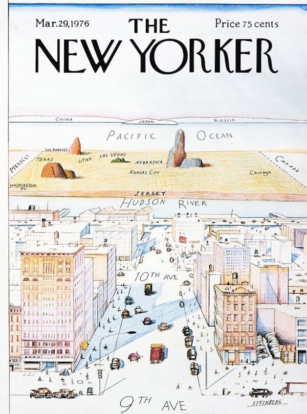
I love this cover, which is from The New Yorker Magazine, published on March 29, 1976, illustrated by Saul Steinberg. Few things capture so succinctly how New Yorkers view their own country west of the Hudson. I stole this particular copy from a lighting shop I worked at in my 20s. RBD framed it for me years later as a Christmas gift. I’ve looked at it almost daily for 20 years now. Only recently, like embarrassingly recently, did I realize Utah and Las Vegas are depicted in the wrong places.
My geography of the American West has always been fuzzy. When speculating about a potential trip West, I wondered aloud if it was possible to do Yellowstone in the morning, have lunch, and hit Arches National Park in the afternoon. RBD laughed at me. Turns out they are 500 miles apart. So forgive me if I thought Los Angles, San Francisco, San Diego, and Sacramento were all … more or less … the same, large metro area. LA is almost 400 miles south of San Francisco, which is nowhere near San Diego. I actually still have no idea where Sacramento fits in to all this.
During the late 1700s California’s acreage was enormous. Spain controlled the territory, and referred to it as Las Californias, or The Californias. Felipe de Neve was Governor, a military man from a young age. Alta California included modern day California, Nevada, and Arizona. Alta means high in Spanish, a reference to the mountainous terrain. Baja California, or Lower California, now belongs to Mexico and includes the Mexican states of Baja California (Tijuana, Mexicali) and Baja California Sur (Cabo). Cabo is known for its stunning beaches, sunsets, and sizable cruise ship passengers day drinking and embarrassing their countrymen.
Los Angeles was originally named “El Pueblo de Nuestra Señora la Reina de los Ángeles del Río de Porciúncula” which translates to “The town of Our Lady the Queen of Angels of the Porciúncula River,” which has since been shorted to LA. Ain’t nobody got time for all that. El Pueblo de Nuestra Señora la Reina de los Ángeles del Río de Porciúncula was one of the longest place names in the world, now abbreviated to one of the shortest.
The city was founded in 1781 by our buddy Governor Felipe de Neve, who also participated in the founding of San Jose, Santa Barbara, and San Diego. Unofficially, he may be among the world’s first urban planners. Neve drew out how he wanted the new pueblo to develop. He was a practicing Christian and Philosopher, who acted remarkably Christ-like (unlike many powerful men of his era, or, really, any era), and is generally regarded as a nice guy who tried to improve the lives of Native Americans within the territory by not harassing or killing them. This contrasts with the slow-burn genocide concurrently happening in Appalachia, which we discussed in Series 7.
If you will recall native peoples were the non-white “thugs” of their day, harassing good Christian Europeans who just wanted to live in peace on land they legally owned. Land they took from these same natives. Rather awkward, really.
It should go without saying, native populations already happily lived in the modern day LA region due to the abundant fresh water and fertile lands. Their name for it was absolutely not El Pueblo de Nuestra Señora la Reina de los Ángeles del Río de Porciúncula. The Tongva, one of the many tribes who lived here, named the region Yangna. White people don’t tend to discover stuff as much as rebrand stuff already discovered, usually to glorify management. In this case, management was King Charles III of Spain, who was looking for riches and glory in all the wrong places. In hindsight The New World (which was decidedly only new to Europeans) had little of either to offer. Spain gave up California in 1821 after The Mexican War for Independence. Mexico ran things until The Mexican-American war in 1848. Remember the Alamo? Well, you shouldn’t. That was Texas. California became the 31st state in 1850.
Neve died in 1784 and his positive legacy remains intact today. There is a statue of him located near Union Station, in what is considered to be the oldest part of the city.
Our trip to El Pueblo de Nuestra Señora la Reina de los Ángeles del Río de Porciúncula is brief but action packed. Tuesday we begin by exploring Koreatown and Downtown, two diverse neighborhoods in a city full of unique, diverse neighborhoods. Wednesday we visit The Getty Museum and have lunch in Malibu. Thursday we’ll hit some touristy sites like The La Brea Tar Pits and The Petersen Automotive Museum. They have an exhibit on Teslas, so we can all look forward to my profanity laden rant on Chief Evil Dipshit Elon Musk.
However, first I must survive a trip through the dreaded El Pueblo de Nuestra Señora la Reina de los Ángeles del Río de Porciúncula International Airport. LAX for short. You all know how leery I am about angering the Gods of JFK. I just hope my offerings appease the Gods of LAX, a group not known for their charity towards privileged New Yorkers who think the East Coast is the best coast.
Here at home we are cleared for departure via runway 3 1 left, departing to the west and straight on the The Rockies. We arrive in LA around 10 PM EDT. Thanks again for joining on our trip to The Eureka State and El Pueblo de Nuestra Señora la Reina de los Ángeles del Río de Porciúncula. Stow your tray tables and fasten your seatbelts. Let’s see what kind of trouble awaits us on the left coast.
From Delta 650, good night.


You must be logged in to post a comment.